


Locus Map 4 Outdoor Navigation


Locus Map 4 Outdoor Navigation ၏ ရွင္းလင္းခ်က္
ချောမွေ့ပြီး ပျော်ရွှင်စရာကောင်းသော ပြင်ပအတွေ့အကြုံအတွက် ဒီဇိုင်းထုတ်ထားသည့် သင်၏ အဆုံးစွန်သော လမ်းညွှန်အက်ပ်ဖြင့် Locus Map ဖြင့် အပြင်ဘက်တွင် စူးစမ်းလေ့လာခြင်း၏ ပျော်ရွှင်မှုကို ရှာဖွေလိုက်ပါ။ သင်သည် သာယာသောလမ်းများမှတစ်ဆင့် တောင်တက်ခြင်း၊ ကြမ်းတမ်းသောမြေပြင်ကိုဖြတ်၍ စက်ဘီးစီးခြင်း သို့မဟုတ် နေရောင်အောက်တွင် စွန့်စားမှုတစ်ခုခုကို စတင်သည်ဖြစ်စေ Locus Map သည် သင့်အား ခြေလှမ်းတိုင်းကို လမ်းညွှန်ရန် ဤနေရာတွင်ရှိသည်။
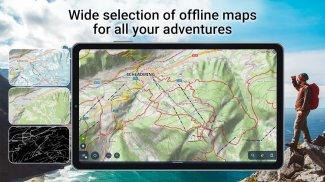
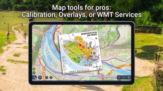
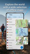
• သင့်ဇာတ်လမ်းကို မြေပုံတစ်ခုဖြင့် စတင်ပါ-
သင်၏စွန့်စားခန်းသည် ပြီးပြည့်စုံသောမြေပုံဖြင့် စတင်သည်။ ကမ္ဘာပေါ်ရှိ နေရာတိုင်းအတွက် အော့ဖ်လိုင်းမြေပုံများ၏ ကျယ်ပြန့်သောရွေးချယ်မှုမှ ရွေးချယ်ပါ။ တောင်တက်ခြင်းနှင့် စက်ဘီးစီးခြင်းအတွက် စိမ်းလန်းစိုပြေသောလမ်းများမှ နိုင်ငံဖြတ်လျှောစီးခြင်းအတွက် နှင်းဖုံးသောလမ်းများအထိ Locus Map က သင့်ကို အကာအကွယ်ပေးထားသည်။ စိတ်ဝင်စားဖွယ်အသေးစိတ်အချက်များ၊ အော့ဖ်လိုင်းလိပ်စာများနှင့် မြေပုံအခင်းအကျင်းများ - တောင်တက်ခြင်း၊ စက်ဘီးစီးခြင်း၊ ဆောင်းရာသီ သို့မဟုတ် မြို့တွင်းသို့ ဝင်ရောက်ကြည့်ရှုခြင်းဖြင့် LoMaps ၏ကမ္ဘာသို့ ဝင်ရောက်ပါ။ အခမဲ့မြေပုံဒေါင်းလုဒ် 3 ခုဖြင့် သင့်ခရီးကို စတင်ပြီး သင့်စွန့်စားမှုအတွက် အဆင့်သတ်မှတ်ပါ။
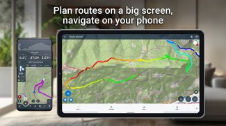
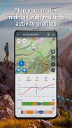
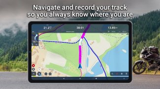
• သင်၏ပြီးပြည့်စုံသောလမ်းကြောင်းကို ဖန်တီးပါ-
သင်အမှတ်အသားပြုထားသောလမ်းများတစ်လျှောက် ခြေရာခံနေသည်ဖြစ်စေ ပွင့်လင်းသောမြေပြင်တွင် သင့်ကိုယ်ပိုင်လမ်းကြောင်းကို ဖောက်သည်ဖြစ်စေ သင့်လမ်းကြောင်းများကို တိကျစွာစီစဉ်ပြီး ပြင်ဆင်ပါ။ သင်၏ စွန့်စားခန်းကို ပုံကြမ်းဆွဲရန် ကျွန်ုပ်တို့၏ ဝဘ် သို့မဟုတ် အက်ပ်အခြေပြု အစီအစဉ်များကို အသုံးပြု၍ အလှည့်တိုင်း၊ တက်ခြင်းနှင့် ဆင်းသက်မှုတို့ကို ဖမ်းစားနိုင်စေပါသည်။ သင့်အစီအစဉ်များကို မျှဝေရန် သို့မဟုတ် သင့်ခရီးတွင် အခြားသူများ၏အတွေ့အကြုံများကို အသက်ဝင်စေမည့် လမ်းကြောင်းများကို ဖော်မက်မျိုးစုံဖြင့် တင်သွင်းခြင်းနှင့် ထုတ်ယူခြင်းလမ်းကြောင်းများ။
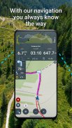
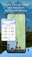
• ချိတ်ဆက်ပြီး စောင့်ကြည့်ပါ-
BT/ANT+ အာရုံခံကိရိယာများနှင့် ချိတ်ဆက်ခြင်းဖြင့် သင်၏ပြင်ပလှုပ်ရှားမှုများကို မြှင့်တင်ပါ။ အကွာအဝေး၊ အမြန်နှုန်း၊ အရှိန်နှင့် ကယ်လိုရီလောင်ကျွမ်းမှုကဲ့သို့သော အသေးစိတ်စာရင်းဇယားများဖြင့် သင့်စွမ်းဆောင်ရည်ကို စောင့်ကြည့်ပါ။ Locus Map သည် သင်၏ဒစ်ဂျစ်တယ်အဖော်ဖြစ်ပါစေ၊ သင်၏တိုးတက်မှုကို ခြေရာခံကာ အသံညွှန်ကြားချက်များ သို့မဟုတ် ရိုးရှင်းသော အသံသတိပေးချက်များဖြင့် သင့်ကိုလမ်းပြပါ။ သင်အမြဲလမ်းကြောင်းမှန်ပေါ်ရောက်ကြောင်း သေချာစေမည့် လမ်းကြောင်းပြင်ပသတိပေးချက်များ နှင့် လမ်းမှားလမ်းညွှန်မှုများဖြင့် လမ်းကြောင်းမှန်ပေါ်ရောက်ပါစေ။
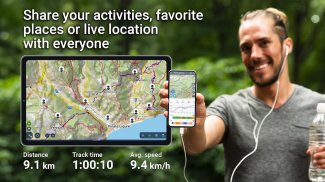
• မှတ်တမ်းတင်ပြီး ပြန်လည်အသက်သွင်းသည်-
သင့်ခရီး၏ အခိုက်အတန့်တိုင်းကို တေးသွားဖြင့် ရိုက်ကူးပါ။ မင်းရဲ့စွန့်စားခန်းကို မြေပုံပေါ်မှာ ဖြန့်ကြည့်လိုက်ပါ၊ မင်းအတွက် အရေးပါတဲ့ ကိန်းဂဏန်းတွေအားလုံးကို အပြည့်အစုံကြည့်ပါ။ သင်အနှစ်သက်ဆုံးနေရာများနှင့် တည်နေရာကို မှတ်သားထားသော ဓာတ်ပုံများ၏ ကိုယ်ရေးကိုယ်တာဒေတာဘေ့စ်ကို ဖန်တီးပြီး ခရီးထွက်တိုင်း ပြောပြရကျိုးနပ်သည်။
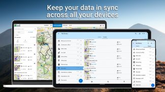
• သင့်ခရီးစဉ်ကို မျှဝေပါ-
Strava၊ Runkeeper သို့မဟုတ် Google Earth ကဲ့သို့သော ပလပ်ဖောင်းများတွင် သူငယ်ချင်းများ၊ မိသားစု သို့မဟုတ် စူးစမ်းလေ့လာသူများနှင့် သင်၏တေးသွားများကို မျှဝေခြင်းဖြင့် သင်၏စွန့်စားခန်းများကို အသက်ဝင်စေပါသည်။ စိန်ခေါ်သော တောင်တက်ခြင်း၊ ရှုခင်းသာစက်ဘီးစီးခြင်း သို့မဟုတ် geocaching ရတနာများ စုဆောင်းခြင်းဖြစ်စေ စိတ်လှုပ်ရှားမှုကို မျှဝေပြီး အခြားသူများကို စူးစမ်းလေ့လာရန် လှုံ့ဆော်ပေးသည်။
• Geocaching နှင့် Beyond-
နှလုံးသားရှိ ရတနာမုဆိုးများအတွက် Locus Map သည် အထူးပြု geocaching ကိရိယာများကို ပေးဆောင်ပါသည်။ အော့ဖ်လိုင်းကစားရန်အတွက် ကက်ရှ်များကို ဒေါင်းလုဒ်လုပ်ပါ၊ တိကျစွာဖြင့် သွားလာနိုင်ပြီး သင့်ရှာဖွေမှုများကို လွယ်ကူစွာ စီမံခန့်ခွဲပါ။ ၎င်းသည် ရိုးရှင်းသော၊ ပျော်စရာကောင်းပြီး ဆုလာဘ်များဖန်တီးထားသည့် geocaching ဖြစ်သည်။
• သင့်အတွေ့အကြုံကို စိတ်ကြိုက်ပြင်ဆင်ပါ-
Locus Map သည် သင်၏စွန့်စားခန်းကဲ့သို့ ထူးခြားသည်။ ပင်မမီနူးမှ စခရင်ဘောင်များ၊ ထိန်းချုပ်ဆက်တင်များနှင့် အခြားအရာများအထိ သင့်လိုအပ်ချက်များနှင့် ကိုက်ညီစေရန် အက်ပ်ကို စိတ်ကြိုက်ပြင်ဆင်ပါ။ အလင်းနှင့် အမှောင်မုဒ်များကြားတွင် ပြောင်းပါ၊ သင်နှစ်သက်သော ယူနစ်များနှင့် ဒက်ရှ်ဘုတ်ကို ရွေးချယ်ကာ ချောမွေ့ပြီး ဘက်စုံသုံးအက်ပ်အတွေ့အကြုံအတွက် ကြိုတင်သတ်မှတ်မှုများ ပြုလုပ်ပါ။
• Premium ဖြင့် အပြည့်အဝစွန့်စားခန်းကို လော့ခ်ဖွင့်ပါ-
Locus Map Premium ဖြင့် အခြေခံများကို ကျော်လွန်ပါ။ အော့ဖ်လိုင်းမြေပုံများ၏ အစုံအလင်ကို ခံစားပါ၊ အော့ဖ်လိုင်းရောက်တာဖြင့် အကန့်အသတ်မရှိ သွားလာပါ၊ ကိရိယာများတစ်လျှောက် သင်၏ရှာဖွေမှုများကို စင့်ခ်လုပ်ပါ။ ဝဘ်ပေါင်းစပ်မှုနှင့်အတူ မျက်နှာပြင်ကြီးတစ်ခုပေါ်တွင် စီစဉ်ပါ၊ သင့်တည်နေရာကို အချိန်နှင့်တစ်ပြေးညီ မျှဝေပါ၊ မြေပုံကိရိယာများနှင့် အားကစားအစုံလိုက်ဝန်ဆောင်မှုများ၏ စွမ်းအားအပြည့်ကို အသုံးချပါ။
မင်းရဲ့ခရီးက စောင့်ကြိုနေတယ်။ ယနေ့ Locus Map ကိုဒေါင်းလုဒ်လုပ်ပြီး ခရီးထွက်တိုင်း မမေ့နိုင်သော စွန့်စားခန်းတစ်ခုအဖြစ် ပြောင်းလဲလိုက်ပါ။ တစ်ချိန်တည်းမှာ ခြေတစ်လှမ်း၊ စက်ဘီးနင်း သို့မဟုတ် စကိတ်ဖြင့် ကမ္ဘာကို အတူတကွ စူးစမ်းကြည့်ကြပါစို့။
Locus Map 4 Outdoor Navigation - ဗားရွင္း 4.27.1
(12-12-2024)

Locus Map 4 Outdoor Navigation - APK သတင္းအခ်က္အလက္
APK ဗားရွင္း: 4.27.1package: menion.android.locusLocus Map 4 Outdoor Navigation ၏ ေနာက္ဆုံးဗားရွင္း
အျခား ဗားရွင္းမ်ား


က႑တူအက္ပ္မ်ား

သင္ႏွစ္သက္ႏိုင္သည္မ်ားမွာ...


